Anak Krakatau’s September Eruption: What the Satellite Images Reveal About Ash, Flights and Public Risk

Anak Krakatau’s early-September eruption was a reminder that a volcano does not need to destroy buildings to disrupt daily life. In this case, a plume of ash and volcanic gases climbed into air routes over Indonesia, temporarily closing airports and forcing airlines to manage a fast-moving aviation hazard. NASA’s Earth Observatory, using Landsat 8 and Suomi NPP observations, documented the event from space.
The eruption began with more than 24 hours of unusually powerful activity. NASA reported that ash reached heights of up to 6,000 metres east of the volcano and 15,000 metres west by 6 September, citing Indonesia’s meteorological agency BMKG. Eight airports in Java and Sumatra were temporarily closed, disrupting nearly 3,000 flights according to contemporary reports cited by NASA. By 8 September, airports had resumed operations, but the end of the flight disruption did not mean the volcano had become irrelevant.
Why ash is an aviation problem
Volcanic ash is made of fine, abrasive particles rather than ordinary smoke. An aircraft engine can ingest the material, where it may melt and then re-solidify on cooler turbine components. That can reduce engine performance and, in a severe encounter, threaten the engine’s ability to operate. Ash can also scratch windscreens and damage sensors. This is why aviation authorities prefer a short closure or rerouting decision to taking an avoidable risk in an ash-contaminated corridor.
Airports therefore rely on a combination of ground reports, satellite imagery, volcano observatory updates and wind forecasts. The same plume can affect one airport while leaving another open a short distance away. Conditions can also change quickly as wind direction shifts or an eruption column rises and collapses. A reopened airport is a sign that the immediate ash hazard has fallen to an acceptable level, not a promise that every route will run on schedule.
What the NASA imagery shows
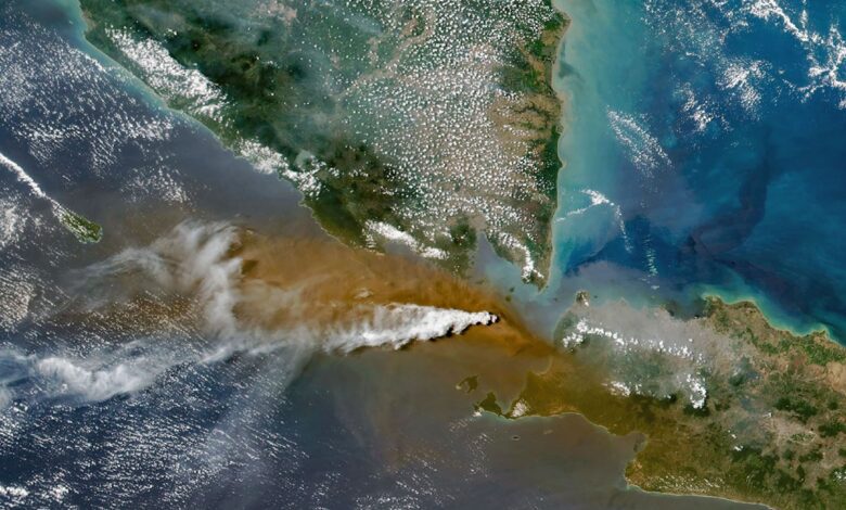
The Landsat image published by NASA shows a white gas plume streaming over a broad brown ash cloud between Java and Sumatra. A wider VIIRS view shows volcanic material spreading beyond the cone over surrounding waters. Satellite images are valuable because they provide a regional picture that cannot be assembled from one observation point on the ground. They help forecasters estimate where ash is moving, compare plume direction with aviation routes and track whether the eruption is intensifying or settling.
NASA said the continuous explosive phase subsided on 6 September. Anak Krakatau continued to rumble and returned to a more typical Strombolian pattern, with intermittent bursts of ash and volcanic material. Indonesia’s alert level remained the second highest on its national scale. That status reflects the volcano’s potential to produce hazardous activity; it does not mean that every nearby community faces the same level of immediate danger.
Public-health precautions
Ashfall is also a health issue. Fine particles can irritate the eyes, nose, throat and lungs, particularly for people with asthma or other respiratory conditions. The Indonesian Humanitarian Coordination Platform, cited by NASA, distinguished volcanic ash from smoke produced by peatland fires because the particles behave differently and require different protection advice. Residents in affected areas are generally advised to follow local authorities, limit exposure when ash is falling, protect eyes and airways and avoid sweeping ash in a way that sends it back into the air.
Why the event matters beyond Indonesia
Anak Krakatau sits near one of the busiest maritime and aviation regions in Southeast Asia. A short-lived eruption can therefore be felt by passengers, cargo operators and businesses far from the volcano itself. It also illustrates why modern volcanic monitoring combines geology, meteorology and satellite engineering. The question is not simply whether lava is visible; it is how ash, gas, wind and infrastructure interact over the next several hours.
The responsible reading of the September event is measured rather than sensational. The eruption caused real disruption and produced a genuine air-quality and aviation hazard, but the available monitoring also showed the explosive phase easing. Travellers should check airline and airport notices rather than rely on social-media videos, while communities near the Sunda Strait should continue following official Indonesian alerts. NASA’s imagery makes the event easier to understand, but local authorities remain the source for operational decisions.
Sources
- NASA Earth Observatory: Anak Krakatau Rumbles Again
- Indonesia’s BMKG monitoring and aviation-weather information
- Smithsonian Global Volcanism Program: Krakatau