
Tropical Storm Edouard threatens Texas and Louisiana with flooding and surge

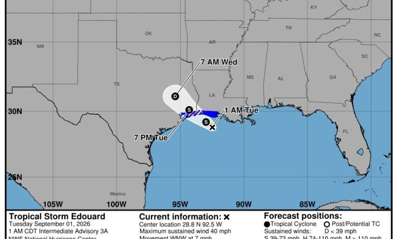
HOUSTON, September 1 — Tropical Storm Edouard was strengthening over the northwestern Gulf of Mexico late Monday, with warnings in effect for parts of the Texas and Louisiana coast. The National Hurricane Center said the centre could approach hurricane strength before reaching the coast on Tuesday, then weaken rapidly after moving inland.
This report reflects NHC Intermediate Advisory 3A, issued at 1 a.m. CDT Tuesday, together with the hazard details in Advisory 3. Forecast positions and warnings can change; residents should use the latest NHC and local National Weather Service products.
Position and forecast track
At 0600 UTC on September 1, reconnaissance aircraft located Edouard near 28.8°N, 92.5°W, about 85 miles southeast of Cameron, Louisiana, and 115 miles southeast of Port Arthur, Texas. Maximum sustained winds remained 40 mph, and the storm was moving west-northwest at 7 mph.
The forecast carried the centre toward the northwest Gulf Coast on Tuesday and inland over southeast Texas Tuesday night. A forecast cone describes the probable path of the centre, not the full area of hazard; rain, surge and wind extend outside it.
Warnings and hazards
A storm-surge warning covered High Island, Texas, to the Vermilion/Cameron Parish line. A hurricane watch extended from High Island to Cameron, Louisiana, and a tropical-storm warning ran from Port Bolivar to the Vermilion/Iberia Parish line.
NHC projected 3–5 feet of inundation above ground somewhere from High Island to the Vermilion/Cameron line if peak surge coincided with high tide, and 1–3 feet farther east to Morgan City. Surge varies over short distances and depends on track, coastline shape and tide.
Rainfall totals of 3–6 inches, with isolated amounts up to 9 inches, were forecast for parts of the upper Texas coast into east-central Texas. Far southwest Louisiana could receive 2–3 inches. The primary inland concern is flash flooding in urban and low-lying areas, with river flooding also possible.
Houston-area preparation
People should avoid flooded roads, charge essential devices, secure outdoor items and know whether local officials have issued evacuation instructions. A hurricane watch means hurricane conditions are possible; it is not a declaration that a hurricane has already made landfall.
Official National Hurricane Center forecast graphic for Tropical Storm Edouard, issued with Intermediate Advisory 3A at 0600 UTC on 1 September 2026. Image: NOAA/NHC, public-domain U.S. government work.