
Flash Flooding Disrupts the New York–Connecticut–New Jersey Corridor: What Officials Reported

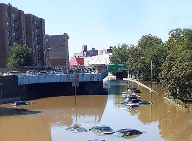
Heavy rain brought flash flooding to parts of coastal Connecticut, New York’s Westchester County and northern New Jersey on September 13, closing roads, triggering water rescues and disrupting rail and air travel across a densely connected corridor. The immediate lesson from the event was not a novel one, but it remains critical: flood danger is driven by how quickly water accumulates, not only by the day’s final rainfall total. The National Weather Service issued flash-flood warnings as thunderstorms produced intense rain, while local emergency services responded to vehicles and homes cut off by rapidly rising water.
The National Weather Service office serving the region said in a September 13 warning that Doppler radar showed thunderstorms producing heavy rain across parts of southern Connecticut. At the time of the warning, between one and one-and-a-half inches of rain had already fallen in some areas, with expected rates of one to two inches in an hour and another one to one-and-a-half inches possible. A warning is a time-specific forecast product, so it should be read alongside later reports of actual impacts rather than treated as a final weather summary.
Where the flooding hit hardest
Associated Press reporting described the hardest-hit areas as northern New Jersey, parts of Westchester County and a coastal stretch of Connecticut along Interstate 95. The report said the Norwalk-to-Westport area received six to seven inches of rain on Sunday morning, with peak rainfall rates of three to four inches an hour. Those concentrated bursts can overwhelm drainage systems, turn roads into fast-moving channels and make conditions dangerous before many people have time to change plans.
In Westport, the fire department conducted 13 rescues of people trapped in vehicles by floodwater, according to the AP report. In Bridgeport, the department said it was fielding repeated calls and using boats to bring people from flooded areas to safety. In nearby New York, White Plains and other communities in Westchester saw road closures and water rescues. Paterson, New Jersey, reported roughly 20 rescues from fast-rising water. These are local operational reports, not a comprehensive regional census of everyone affected.
Travel disruption spread beyond flooded streets
The flooding affected a corridor used daily by commuters, intercity travellers and freight services. Metro-North and Amtrak reported delays and cancellations on routes toward New Haven, including service that connects communities such as Norwalk and Bridgeport. Tweed New Haven Airport closed its departures terminal because of local flooding and told departing passengers not to come to the airport until further notice. The disruption showed how a short period of concentrated rainfall can affect roads, rail lines and airport operations at the same time.
That wider disruption does not mean every route or facility was closed for the same reason or for the same duration. Conditions varied substantially across the tri-state area. Readers making travel decisions should use live notices from their carrier, airport, municipal emergency managers and the National Weather Service rather than relying on a single regional news update. Floodwater can recede unevenly, and hazards such as debris, damaged pavement and stalled vehicles can persist after rain eases.
Public-safety advice from the response
Connecticut officials urged drivers to avoid flooded roads and not attempt to drive through standing water. That advice is backed by the basic physics of flash floods: moving water can conceal washouts, lift a vehicle or push it into a deeper channel; still water can hide damaged pavement, open drains and electrical hazards. Barriers, detours and instructions from emergency crews should be treated as life-safety measures, not as inconveniences to bypass.
People in affected areas also need to distinguish between an active warning and an ordinary forecast. A flood watch means conditions may support flooding. A flash-flood warning means flooding is occurring, imminent or highly likely in the warned area. The correct response depends on the situation, but it may include moving to higher ground, avoiding low-lying routes and never entering water to retrieve a vehicle or belongings. Anyone facing an immediate emergency should contact local emergency services.
What this event does and does not establish
The reports reviewed for this article documented rescues, closures and transport disruption. They did not provide a confirmed regional death toll, so none should be inferred. Nor should a single heavy-rain event be presented as proof of a particular climate trend. Scientists study climate through long-term patterns and attribution research, while this event first requires a clear account of local rainfall, flood response, damage and recovery. Keeping those questions separate makes the coverage more accurate, not less urgent.
It is also important not to use dramatic social-media clips without checking their location and date. Flood imagery is often recirculated after unrelated storms. Official weather alerts, emergency-service statements and service-provider notices remain the most reliable way to understand whether a warning applies to a particular neighbourhood, route or travel plan.
What to watch next
As water recedes, local agencies will assess roads, drainage, rail infrastructure and public facilities. Transport operators will update service restoration, and municipal officials may issue guidance about debris, property damage or future weather threats. The immediate news is clear: intense rain caused flash flooding across parts of Connecticut, New York and New Jersey, emergency crews carried out rescues, and a major travel corridor experienced interruptions. The continuing story is how quickly communities can return safely to normal operations.