Fact Check: Nepal Flood Is Real, but Viral Chinese Dam-Rupture Videos Are AI-Generated

Verdict: The catastrophic Nepal-Tibet flood is real, and an unstable natural barrier lake did breach and overflow. However, there is no verified evidence that a large constructed Chinese hydroelectric dam collapsed. Several viral videos promoted as proof of such a rupture are AI-generated, old or filmed elsewhere.
What happened in reality
On August 26, a massive section of bedrock, glacier ice and snow collapsed near the Himalayan border. The resulting debris entered the river system and produced an exceptionally fast surge of water, mud, rock and ice through Gyirong and downstream areas of Nepal.
The collapse temporarily blocked watercourses and later created another barrier lake. Nepal issued a second warning after receiving information that this natural blockage had breached or begun releasing water. Calling it a “dam” is technically possible, but it was a debris-and-ice barrier created by the disaster—not a concrete power-generation structure.
Which viral videos are false?
One widely shared clip shows a large bridge or dam-like structure collapsing into floodwater. Frame-by-frame inspection found inconsistent architecture, distorted vehicles and objects changing shape, while automated analysis rated the sequence as AI-generated.
Another video claims that an F-16 or missile bombed a dam and caused the Nepal flood. Earlier copies were online months before the August 26 disaster and included an AI watermark. Similar fictional clips from the same creator showed aircraft attacking other dams.
A separate montage showing a missile followed by a huge dam collapse was also digitally generated. Other genuine-looking footage circulated with the wrong location: videos from earlier floods in India and Myanmar were relabelled as current scenes from Nepal.
What authentic evidence looks like
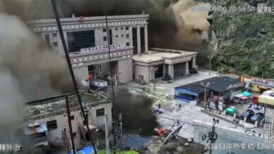
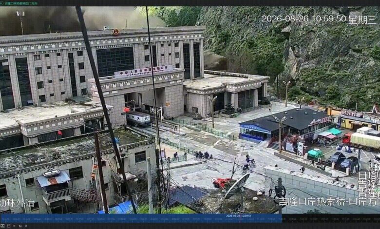
Real fixed-camera footage from Gyirong Port shows people running as a dark wall of water and debris enters the border facility. The time stamp, fixed landmarks and multiple stages of the same sequence can be matched across independent publications.
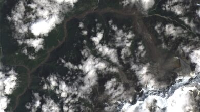
Satellite images taken before and after the event show the bedrock and glacier collapse, the debris path and changes to the valley. Official rescue images also show consistent geography, personnel and equipment across several viewpoints.
How to check a dramatic disaster clip
- Find the earliest upload. A video posted before the event cannot document it.
- Look for creator or AI-tool watermarks, especially when later reposts crop them out.
- Compare buildings, mountains, road signs and river direction with verified imagery.
- Watch for vehicles changing size, repeating debris, impossible water behaviour and structures that deform between frames.
- Use reverse-image search to identify older versions or a different location.
- Wait for confirmation from emergency agencies, satellite analysts or several independent news organisations.
The correct conclusion
It would be wrong to dismiss the Nepal-Tibet disaster as an AI hoax: hundreds of deaths, widespread destruction and a major rescue operation are independently documented. It would also be wrong to use that real tragedy to authenticate every spectacular clip posted online.
The evidence supports a natural ice-rock and debris-chain disaster followed by concern over a natural barrier lake. It does not support claims that a man-made Chinese dam was destroyed by structural failure, sabotage, a missile or an aircraft.