Anak Krakatau Eruption Eases, but Level III Alert Remains After Airports Reopen

Indonesia reopened airports serving Jakarta and nearby regions on Tuesday after volcanic ash from Anak Krakatau disrupted air travel for two days. The return of flights is an important sign that aviation conditions have improved, but it is not an all-clear for the volcano itself.
Anak Krakatau remained active on the morning of 8 September. Two eruptions were recorded at 5:08 a.m. and 5:34 a.m. local time, although cloud and fog prevented observers from measuring the ash columns. Indonesia’s volcanology authorities continue to keep the volcano at Level III, or Siaga, the second-highest level in the country’s four-stage system.
What happened at Anak Krakatau?
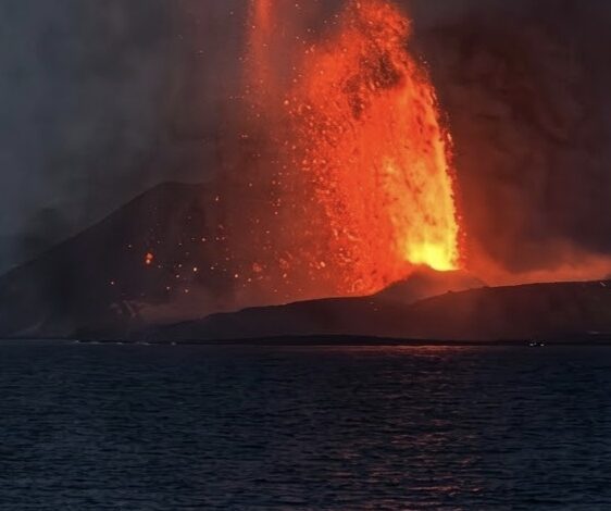
The most intense recent phase began at 11:07 p.m. on 4 September and continued until 12:04 a.m. on 6 September, a period of roughly 25 hours. Monitoring instruments recorded continuous eruptive earthquakes while cameras and observation posts captured incandescent lava fountains, dark ash emissions and repeated booming or rumbling sounds.
The end of that continuous episode means the eruption has shifted rather than necessarily finished. Moderate, intermittent bursts and small local volcanic earthquakes continued after the sustained phase stopped. The official alert level therefore remains unchanged, and the exclusion zone around the active crater is still in force.
Ash reached major aviation corridors
Satellite monitoring by Himawari and the Darwin Volcanic Ash Advisory Centre detected ash reaching about flight level 480, approximately 14.6 kilometres above sea level, during the eruption. The plume initially moved mainly west to southwest, but ash trajectories can change quickly with wind speed and direction.
That uncertainty forced aviation authorities to close Jakarta’s Soekarno-Hatta and Halim Perdanakusuma airports and several regional airports. The disruption affected nearly 2,961 flights, including 622 international services, and approximately 341,000 passengers. Airports reopened only after safety assessments, while airlines were instructed to inspect aircraft and crews were warned to avoid restricted airspace.
Volcanic ash is not ordinary smoke. Its fine, abrasive mineral particles can damage aircraft engines, windscreens and sensors even when visibility at ground level appears acceptable. Travellers should continue checking directly with their airline and airport because routes can be changed again if a fresh plume crosses flight paths.
Communities experienced ash and distant booms
Ashfall was reported across seven districts of Serang in Banten: Anyer, Cinangka, Ciomas, Mancak, Pabuaran, Baros and Padarincang. Coastal communities in parts of Lampung and Banten also reported rumbling or vibrations. Volcanologists said the distant sounds were consistent with powerful acoustic energy from the eruption travelling through particular atmospheric layers; there was no significant tectonic earthquake in West Java that explained them.
Schools in areas affected by ash were allowed to move temporarily to online learning to reduce children’s exposure. Disaster agencies sent personnel to affected locations, checked evacuation routes and shelters, reviewed sirens and contingency plans, and monitored stocks of food and protective supplies. No disaster-emergency status had been declared by affected local governments in the early response, and no deaths were reported.
What the Level III alert means
The current safety instruction applies to residents, visitors, tourism operators and fishers: nobody should approach within three kilometres of the active crater. People should not travel toward the island simply to watch or record the eruption because explosive bursts can throw hot material beyond the vent with little warning.
Level III signals heightened activity and the possibility of dangerous changes. It does not mean that a catastrophic eruption or tsunami is certain. Anak Krakatau’s 2018 flank collapse generated a deadly Sunda Strait tsunami, but authorities have not issued a comparable tsunami warning for the current episode. Officials are monitoring both volcanic activity and changes in the volcano’s shape; unverified tsunami messages should not be circulated as fact.
Residents exposed to falling ash should follow local health and disaster-management advice, limit unnecessary outdoor activity, use a well-fitting mask and eye protection when outside, and protect drinking water and food from contamination. Anyone with breathing difficulty should seek medical help, particularly children, older adults and people with asthma or other respiratory conditions.
Why close monitoring will continue
Anak Krakatau lies in the Sunda Strait between Java and Sumatra and has been at Level III since July. It is one of more than 120 active volcanoes in Indonesia, an archipelago positioned along the tectonically active Pacific Ring of Fire. Frequent activity is part of the region’s geology, but the volcano’s location near densely populated coasts and important air routes makes careful monitoring essential.
The immediate transport crisis has eased, yet two facts remain important: eruptions were still occurring on Tuesday morning, and the three-kilometre danger zone remains mandatory. The most reliable updates are those issued by PVMBG and the Geological Agency through MAGMA Indonesia, alongside notices from BNPB, local disaster agencies and aviation authorities.
Sources
- BNPB eruption and ash-distribution update
- Indonesian government update on the Level III alert
- Latest airport and eruption update
- Featured-image provenance and public-domain record