Hurricane Lowell weakens from Category 5 but remains a 155 mph threat south of Hawaii

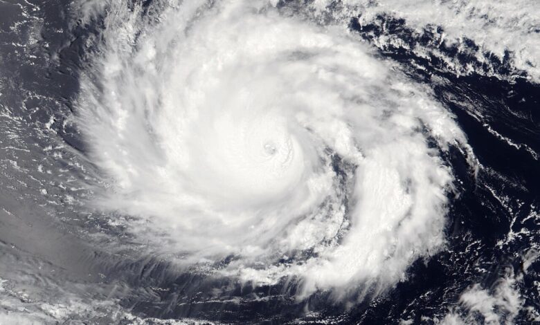
Hurricane Lowell weakened slightly from Category 5 intensity but remained an extremely powerful Category 4 hurricane with maximum sustained winds of 155 mph, according to the official 5 p.m. HST advisory on September 2.
The National Hurricane Center placed the centre near 13.3°N, 155.2°W—about 440 miles south of Hilo, Hawaii—moving west at 10 mph. No coastal watches or warnings were in effect at the advisory time.
Why the absence of a warning is not the same as no hazard
Lowell’s centre was forecast to remain well south of the main Hawaiian islands, but swells generated by the hurricane were expected to reach Hawaii. Large surf and life-threatening rip currents can occur far from a cyclone’s core, including under otherwise fair skies.
A Category 4 label describes maximum sustained wind near the centre. It does not by itself show the size of the wind field, waves, rainfall or local coastal risk. People should follow lifeguard instructions and official National Weather Service products rather than approaching the shoreline to observe waves.
The forecast can change
Major hurricanes can fluctuate quickly because of eyewall changes and ocean-atmosphere conditions. Track and intensity forecasts also contain uncertainty even when the centre line appears precise.
This report is time-stamped to Advisory 27, issued at 0300 UTC on September 3. Readers should consult the latest NOAA advisory before making decisions, as later bulletins supersede the figures above.
Sources: NOAA/NHC Hurricane Lowell Advisory 27; official Lowell advisory archive.
Hurricane Lowell south of Hawaii on September 2. Satellite image: NOAA-21/VIIRS via NASA Worldview, public domain.