Typhoon Saudel Threatens Japan, Taiwan and China With Destructive Weather

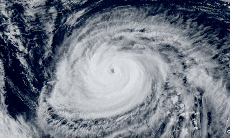
Typhoon Saudel is moving west-northwest across the western Pacific, threatening Japan’s southern islands before approaching Taiwan and China’s coast with destructive winds, high seas and heavy rain. The storm had sustained winds near 162 kilometres per hour and gusts reaching 216 kilometres per hour on Tuesday as regional weather agencies urged people to prepare.
Saudel was advancing at about 20 kilometres per hour. Forecast tracks can change, and the area of damaging weather extends well beyond a cyclone’s centre, so communities outside the most likely path still face risks from rain, waves and sudden gusts.
Japan’s southwestern islands face the first impact
Japan’s weather agency warned of violent winds and dangerous seas around Okinawa and other southwestern islands. Islands exposed to an approaching typhoon can lose ferry and air connections before the strongest conditions arrive, making early decisions about supplies, medical needs and shelter especially important.
Residents should secure loose objects, avoid coastal roads and follow evacuation instructions. High waves can reach shore before land winds peak, while saturated slopes can fail after repeated rain. Power cuts and communications interruptions are also possible in smaller communities where repair crews must wait for conditions to improve.
Taiwan watches the northern edge
Taiwan’s Central Weather Administration assessed the probability of a direct landfall as low, but said northern Taiwan and the Matsu Islands could be affected from late Thursday into Friday. A near miss can still produce severe coastal weather, particularly if the storm expands or shifts south of the current forecast.
Authorities are responding after a separate tropical depression brought exceptional rainfall to southern and eastern Taiwan. That system left one person dead and four missing, while parts of Kaohsiung received close to 1,000 millimetres of rain over three days. Those impacts should not be attributed to Saudel, but they leave some areas more vulnerable to further rain and transport disruption.
Repeated systems also strain emergency services. Reservoir and river managers must balance flood control with water storage, while crews clearing landslides and damaged roads may be exposed to a new period of hazardous weather.
China prepares for high waves
Saudel is expected to continue toward the Chinese province of Fujian after passing the Taiwan area. Chinese authorities issued an orange alert for ocean waves, with forecasts of seven to 12 metres in parts of the East China Sea. Ports, fishing fleets and offshore operations face the most immediate danger from seas of that size.
Coastal cities may also experience storm surge, heavy rain and transport closures even if the typhoon weakens before reaching land. The timing of the storm relative to local tides will influence flooding, and rainfall over mountainous terrain can rapidly feed rivers downstream.
Preparation matters more than the centre line
Forecast maps often show a single track, but that line is not a precise prediction. Cyclones wobble, grow and weaken as they interact with sea temperatures, upper-level winds and land. Emergency planning should therefore use the full forecast cone and official local warnings rather than assuming safety because a home lies away from the centre.
Travellers should check flights and ferries before departure. Households in exposed areas should charge devices, store drinking water, protect essential medicines and know the safest nearby shelter. People should never enter floodwater or approach sea walls to watch large waves.
Climate change does not create an individual typhoon, but warmer oceans and a warmer atmosphere can increase the moisture available to the strongest storms and raise coastal flood levels through sea-level rise. That makes resilience in ports, drainage, communications and housing increasingly important across the region.
Saudel’s exact land impacts will become clearer as the system moves west. Until then, the responsible course is to treat official warnings seriously across Japan’s southern islands, northern Taiwan and China’s eastern coast, including places that may not experience the storm’s eye.